Explore
Future Risks.
Our flood forecasting system provides global and finer-resoluted regional forecasts upto 10 days ahead.
Explore the future flood risks globally with our system.
Photo: Kinu River Flood of 2015, Japan
Important Notice: Currently we are implementing an update for the global system.
Because of this, we stop the dissemination of global forecasts temporally. Sorry for the inconvenience.
How we forecast floods
The system consists of three components:
Numerical Weather Predictions (NWPs), a Land Surface Model (LSM), and a hydrodynamic model.
Firstly, the LSM calculates runoff by solving surface physics with NWPs.
Then the hydrodynamic models simulates river dynamics with calculated runoff and estimates potential flood area.
Hurricane Harvey of 2017, Texas
Models
MATSIRO (Minimal Advanced Treatments of Surface Interaction and Runoff)
Firstly developed by Takata et al. (2003), MATSIRO has been a land surface component of CCSR/NIES/FRCGC AGCM (Numaguchi et al., 1997). This model considers the water and energy interactions between a land surface with a vegetation canopy and atmosphere. The surface runoff and baseflow were calculated independently using Horton flow and the advanced application in TOPMODEL (Beven & Kirkby, 1979), respectively. For the baseflow calculation, the standard deviation in elevation and the average slope from a fine resolution digital elevation model (DEM) were considered to represent the flow characteristics in each coarse model grid cell. Assuming a quasi steady state of groundwater level, baseflow was calculated from the groundwater recharge rate given by the soil water dynamics. MATSIRO has been used various hydrological studies from global to regional research.
(figure from http://hydro.iis.u-tokyo.ac.jp/~sujan/research/models/matsiro.html)
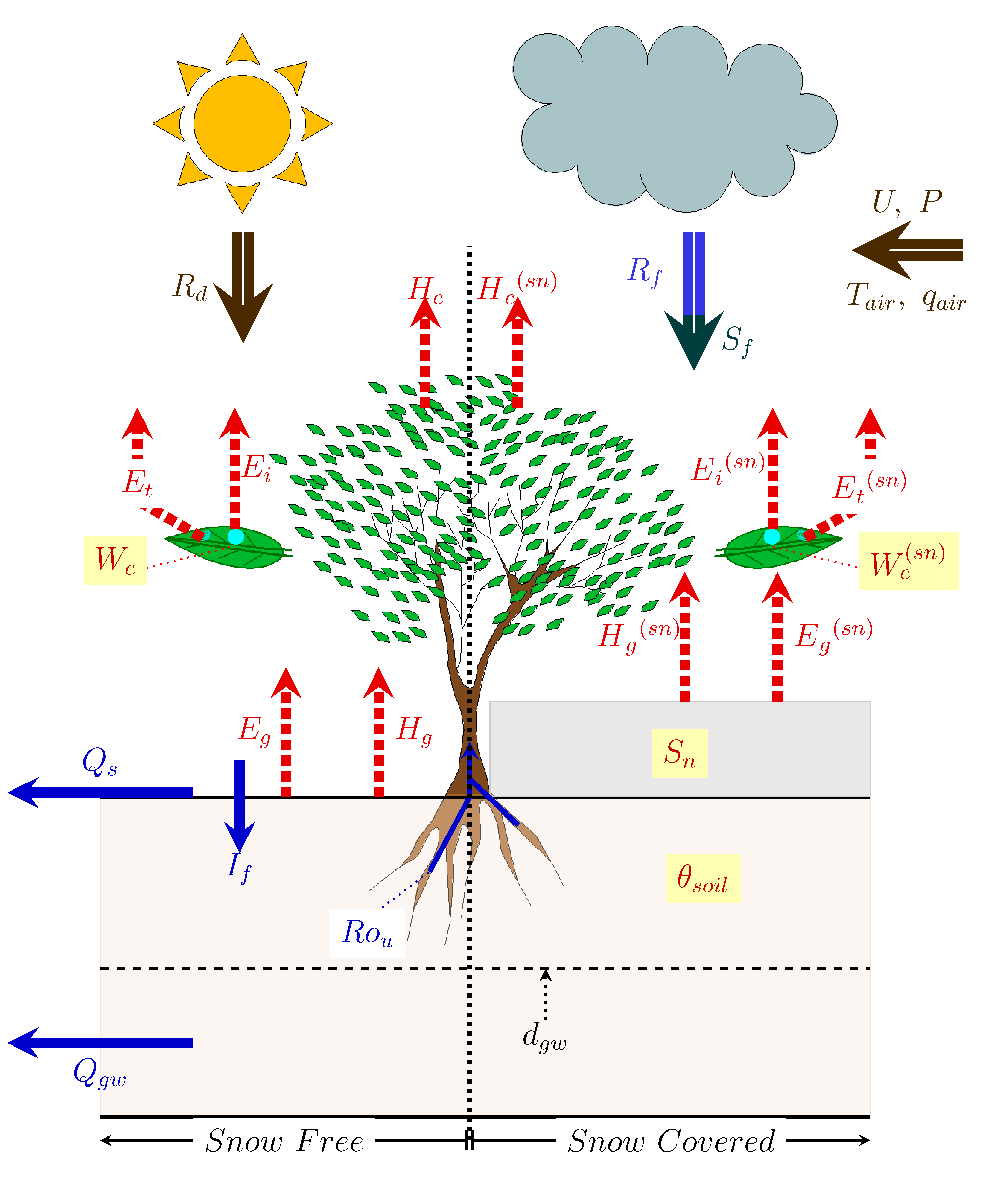
Schematic diagram of MATSIRO
CaMa-Flood (Catchment-based Macro-scale Floodplain)
CaMa-Flood was developed by Yamazaki et al. (2011) which enables hydrodynamic simulation with floodplain on a global scale. The model solves the local inertial equation (Bates et al., 2010); it neglects the advection term of the full 1D St. Venant equation. It considers a rectangular river channel and trapezium flood plain storage, and represents flood plain dynamics assuming that the elevation profile of the floodplain monotonically increases in each pixel. The river network, routing direction, and river parameters were derived from three arcs of the Shuttle Radar Topography Mission DEM (Farr et al., 2007) and HydroSHEDS (Lehner et al., 2008) by the Flexible Location of Waterways (FLOW) method (Yamazaki et al., 2009), without neglecting the finer topographic information of the DEM in the coarse model grid cells.
(Developer's web site: http://hydro.iis.u-tokyo.ac.jp/~yamadai/cama-flood/
Hydrodynamic simulation by CaMa-Flood (v3.6). Calculation at 0.1 degree resolution, flood depth is diagnostically downscaled onto 500m resolution DEM.
Reference
Bates, P. D., Horritt, M. S., & Fewtrell, T. J. (2010), A simple inertial formulation of the shallow water equations for efficient two-dimensional flood inundation modelling. Journal of Hydrology, 387(1–2), 33–45. http://doi.org/10.1016/j.jhydrol.2010.03.027
Beven, K. J., & Kirkby, M. J. (1979), Physically based, variable contibution area model of basin hydrology. Hydrological Sciences Bulletin. http://doi.org/10.1080/02626667909491834
Farr, T. G., Rosen, P. A., Caro, E., Crippen, R., Duren, R., Hensley, S., ... Alsdorf, D. (2007), The Shuttle Radar Topography Mission. Reviews of Geophysics, 45, 1–33. http://doi.org/10.1029/2005RG000183.
Lehner, B., Verdin, K., & Jarvis, A. (2008), New global hydrography derived from spaceborne elevation data. EOS, 89(10), 93–104.
Numaguchi, A., M. Takahashi, T. Nakajima and A. Sumi (1997), Description of CCSR/NIES atmospheric general circulation model. CGER Supper Computer Monograph Report No.3, 1–48. Center for Global Environmental Research, National Institute for Environmental Studies
Takata, K., Emori, S., & Watanabe, T. (2003), Development of the minimal advanced treatments of surface interaction and runoff. Global and Planetary Change, 38(1–2), 209–222. http://doi.org/10.1016/S0921–8181(03)00030–4
Yamazaki, D., Kanae, S., Kim, H., & Oki, T. (2011), A physically based description of floodplain inundation dynamics in a global river routing model. Water Resources Research, 47(4), 1–21. http://doi.org/10.1029/2010WR009726
Yamazaki, D., Oki, T., & Kanae, S. (2009), Deriving a global river network map and its sub-grid topographic characteristics from a fine-resolution flow direction map. Hydrology and Earth System Sciences, 13(11), 2241–2251. http://doi.org/10.5194/hess-13–2241–2009